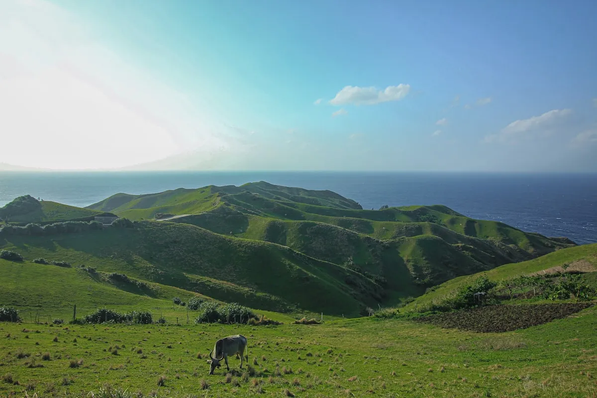
The path rises steeply through grass that is impossibly green — the saturated, electric green of a place that gets 200 centimetres of rainfall a year and where the sun, when it emerges, hits everything with the particular clarity of a high-latitude light. To the east, the Pacific. To the west, the South China Sea. Below, stone-roofed Ivatan houses sit in their valleys, exactly as they have sat for five centuries, engineered against the typhoons that hammer this northernmost edge of the Philippines with a regularity and fury that would flatten ordinary construction.

Batanes Trekking Guide: Rolling Hills, Lighthouse Walks & the Islands' Best Trails
Trip.com
Search on Trip.comHotels in Philippines
Compare live prices via Travelpayouts — targeted for this guide.
This is Batanes, the Philippines' northernmost island group, 162 kilometres north of the main Luzon coastline and 190 kilometres south of Taiwan. And the walking here — not technical mountaineering, but genuine trail-based exploration through extraordinary scenery — is among the most rewarding in the country.
Understanding Batanes Trekking: It's Nature Walking, Not Technical Climbing
Let's set expectations correctly. Batanes trekking is primarily nature walking on accessible trails through scenery that happens to be extraordinary — rolling volcanic hills, cliff-edge coastal paths, ancient stone-house villages, lighthouse headlands above crashing Pacific surf. The routes are not technical. You do not need mountaineering experience, specialized equipment, or a high fitness level.
What you do need: comfortable walking shoes with grip (trails get muddy after rain, which happens regularly), a light rain jacket (wind and occasional rain are constant companions even in the dry season), a sense of direction or a local guide for the less-obvious routes, and the willingness to climb some genuinely steep grass slopes where the reward at the top is a 360-degree view that will stop you breathing for a moment.
Trip.com
See all tours in Philippines on Trip.comHiking tour in Philippines
Hand-picked experiences in Philippines — book on Trip.com with instant confirmation.

Batanes also has one enormous practical advantage over other Philippine trekking destinations: you can use a scooter to reach trailheads. The islands have an excellent road network (built to withstand Batanes-grade typhoons — which is to say, built extraordinarily well). Rent a scooter for PHP 400–500 per day, ride to the trailhead, walk the trail, ride to the next one. This approach lets a fit walker cover 3 to 4 significant trails in a single day.
Batan Island Trails
Vayang Rolling Hills — The Signature Walk
The Vayang Rolling Hills in the northwestern corner of Batan Island are Batanes' most photographed landscape — a series of emerald volcanic hills dropping in layers toward the sea, with the South China Sea spread to the horizon beyond. The area was made internationally famous by a cigarette advertisement decades ago and is still sometimes called "Marlboro Country," though the hills themselves are spectacular enough not to need the marketing.
The walking route through Vayang takes approximately 2 hours for a circuit from the road end. The path climbs and descends between the rounded hill summits, with ocean visible in nearly every direction. There are no marked trails — you navigate by eye, following the grass ridgelines. On clear days, the island of Itbayat is visible to the north. In misty conditions, which are common, the hills become even more atmospheric — rolling green shapes emerging from low cloud, cattle grazing silhouettes, the wind constant and cold. Scooter to the road end, then walk.
Naidi Hills to the Basco Lighthouse
The Naidi Hills above Basco (the provincial capital) lead to the iconic Basco Lighthouse, an old stone lighthouse on a headland above the Pacific. The walk from the edge of Basco town through the Naidi Hills to the lighthouse takes approximately 1.5 to 2 hours return, gaining around 150 metres of elevation through grassland with increasingly dramatic views over Basco Bay and the Pacific coast. The lighthouse itself is photogenic and the views from the headland on a clear day — north toward Taiwan, east across open Pacific — are legitimately breathtaking. Bring a wind layer; the headland exposure is significant.
Radar Tukon Viewpoint Walk
The old US radar station on Tukon Hill, now an abandoned facility with a distinctive dome structure, is reached by a short walk of approximately 1 hour return from the road above Basco. The elevation provides one of the best all-round views of Batan Island — Basco and its harbor to the east, the rolling interior to the south, the coastline in both directions. Often used as a sunset viewpoint, with the low light turning the hills gold and the harbor below coming to life with fishing boat lights. Short and easy enough to combine with the Naidi Hills route in a single afternoon.
Valugan Boulder Beach Coastal Path
The northeastern coast of Batan is fringed by Valugan Boulder Beach — a dramatic stretch where the Pacific has deposited enormous rounded boulders, some the size of small cars, in a grey-black mass along the shoreline. The walking path along this coast, approximately 2 hours one-way, connects the boulder beach to the Chanarian area through a route that alternates between cliff tops and sea-level boulder hopping. Dramatic even in calm weather; spectacular when Pacific swells are running. Do not attempt in rough seas — rogue waves on boulder beaches are dangerous. Take a tricycle back from Chanarian rather than walking the return.
Sabtang Island Trails
Sabtang Island, 20 minutes by faluwa (traditional wooden boat) from Ivana port on southern Batan, offers some of the most rewarding walking in Batanes. The island is smaller and quieter than Batan, with fewer tourists, traditional stone-house villages largely intact, and coastal scenery that matches or exceeds Batan's best.
Chavayan to Savidug Village Coastal Walk
The classic Sabtang walk connects Chavayan and Savidug — two of the island's intact traditional villages — via a coastal cliff path. The route takes approximately 1.5 to 2 hours one-way and follows the western coastline on cliff-top paths above the South China Sea. Both villages are well-preserved examples of Ivatan architecture: lime-and-stone houses with thick cogon-grass roofs designed to withstand typhoon winds. The transition from Pacific-facing Chavayan to the more sheltered Savidug, with its harbor and stone-paved lanes, gives the walk a satisfying narrative arc. Tricycle or hired vehicle back to the Sabtang port for the faluwa home.
Savidug to Chamantad-Tinyan Viewpoint
From Savidug village, a 1 to 1.5 hour walk uphill reaches the Chamantad-Tinyan viewpoint — arguably the finest panoramic view in all of Batanes, looking north over the island's rolling interior and south toward Batan across the channel. The climb is steep in sections but the path is clear. Return to Savidug the same way or continue along the ridge (more challenging, guide recommended).
Lighthouse Trail, Sabtang
The old lighthouse on Sabtang's northern tip requires a full half-day from the port: a vehicle or walk to the trailhead near Nakabuang Arch, then a coastal walk to the lighthouse on headland cliffs. The Nakabuang Arch itself — a natural arch carved by Pacific waves through a rocky headland — is worth the trip alone. The complete circuit including the arch and the lighthouse viewpoint takes approximately 3 to 4 hours. A guide from Sabtang town (PHP 500–800 for the day) is advisable for this route as the coastal paths above cliffs require confidence.
Itbayat Island: For Serious Adventurers Only
Itbayat, the largest of the Batanes islands and the most remote, requires a 3 to 5 hour faluwa ride from Batan in calm weather (this trip is suspended frequently due to rough seas) and offers walking through genuinely untouched landscape. There are no established tourist trails and no consistent trail markers. The island's interior is a plateau of volcanic rock and scrub, with dramatic cliff edges dropping to the sea and a unique terrain unlike the rolling hills of Batan.
Visiting Itbayat requires: advance coordination with Batanes' tourism office, a local guide (mandatory — several community guides can be arranged through the Itbayat LGU), overnight accommodation in the village (basic but available), and significant flexibility on timing (the faluwa does not run in rough weather and Itbayat's isolation means weather windows matter). Traditional rope-basket payao transport for cargo — not for tourists — is used on the steep sea cliffs for supplies. Budget 2 to 3 days minimum for the Itbayat experience.
Weather: The Critical Variable in Batanes
Batanes is subject to the most severe weather conditions of any tourist destination in the Philippines. Located at the intersection of three weather systems — the Pacific typhoon belt, the northeast monsoon, and the southwest monsoon — the islands see typhoons, dense fog, and violent wind with regularity.
- Best months for trekking: March through May (relatively dry, fog less frequent, seas calmer for inter-island travel)
- Good months: November through February (the dry amihan season reaches Batanes, cool and often clear)
- Avoid: June through October (typhoon season — the islands can be battered for days at a time; flights cancel, faluwa service suspends, trails become slippery and dangerous)
Even within the "good" season, fog can descend suddenly and paths can become slippery within minutes of rain. Always carry a rain jacket. If fog closes in on a ridge walk, stop and wait — disorientation in featureless fog on a cliff-edge island is genuinely dangerous.
Practical Logistics
Getting to Batanes: SkyJet Airlines and Philippine Airlines operate flights from Manila to Basco Airport. Flights are small aircraft (ATR 72 or smaller), weather-dependent, and frequently delayed or cancelled. Budget extra days on either end of your Batanes trip specifically to absorb flight disruptions. Fares: PHP 3,000–6,000 one-way depending on timing.
Scooter rental: The most practical transport for island exploration. Available at the airport and in Basco town. PHP 400–500/day, no international driving licence required (technically required but enforcement is informal in Batanes). Bring a licence anyway.
Cash: ATMs in Basco exist but are unreliable and sometimes empty. Bring sufficient PHP cash from Manila for your entire stay.
Frequently Asked Questions
Do I need a guide for Batanes trekking?
For the main Batan Island trails — Vayang, Naidi Hills, Radar Tukon, Valugan coast — a guide is optional. The paths are generally followable and the scenery is forgiving of minor route variations. For Sabtang island's more remote coastal routes and particularly for Itbayat, a local guide is strongly recommended for both navigation and safety. Guides can be arranged through your accommodation or the Batanes tourism office in Basco (PHP 500–1,000 per day for a local guide).
How many days should I spend in Batanes?
Minimum 3 nights on Batan plus ideally a day trip to Sabtang. The standard recommended itinerary is 4 nights total: 2 days exploring Batan's trails and villages, 1 day on Sabtang (day trip or overnight), and 1 buffer day for inevitable weather disruptions. Adding Itbayat requires 2 additional days minimum. Most visitors find that Batanes expands to fill available time — it is the kind of place where sitting on a hillside watching weather move across the Pacific counts as a fully satisfying activity.
What is the best season to visit Batanes?
March to May is the optimal trekking window: relatively low rainfall, calmer inter-island seas, and good visibility on most mornings. November and December are also good, with the northeast monsoon bringing cool, generally clear weather. Avoid June through October if possible — typhoon season in Batanes is no joke, and flight cancellations can strand visitors for days.
Are Batanes trails suitable for beginners?
Yes — the Batan Island trails are accessible to anyone with basic fitness and comfortable walking shoes. There is no technical terrain, no rope work, and no extreme altitude. The main challenges are wind (constant and sometimes strong), occasional muddy conditions after rain, and some steep grass slopes. If you can walk comfortably for 2 to 3 hours, you can handle Batanes trekking. Itbayat is the exception — the untracked terrain there requires significantly more navigation confidence.
What should I pack for Batanes hiking?
Layers are essential — Batanes is significantly cooler than mainland Philippines, especially at dawn and on exposed hilltops. A wind-resistant light jacket, a packable rain layer, and a midlayer fleece or long-sleeve shirt are the core clothing items. Sturdy closed-toe footwear with reasonable grip handles both grassy slopes and muddy post-rain paths. Bring more water than you think you need — there are no shops on the trails. A small daypack (20–25L) is sufficient for a day's walking. Sunscreen matters even in overcast conditions — UV at altitude and sea reflected light is significant.

PANA.PH Editorial Team
Philippines travel desk
The PANA.PH travel desk researches, books and re-checks Philippines travel logistics — fares, ferry schedules, government fees and permit rules — and publishes what it can verify.
🏡 Real local stays (book direct)
Hand-picked homestays and guesthouses — book direct, no markup.
Browse all local stays →
🌊 Popular activities (book instantly)
Island hopping, canyoneering, whale sharks — real Klook/GetYourGuide options.
View all activities →